
NEXUS AI / PROJECT IMPORT
Someone else's drawing, checked and posted as a project in your GIS.
Project Import takes a design produced outside the GIS, imports it, runs the analysis checks against it, and posts what passes as a project carrying the validation you require. What does not pass is reported rather than quietly loaded.
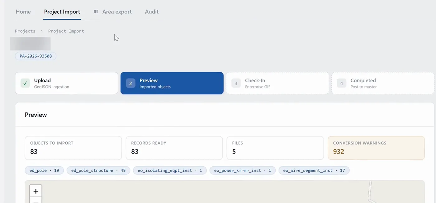
A drawing arrives from a contractor as a set of files. Nexus reads them, works out what each object is, and shows you the count by type and every conversion warning it raised — all of it before a single record is written. Nothing is posted until you move it on, and the quality checks that follow run here rather than in the GIS.
Not every design starts inside the utility. Contractors, developers and engineering firms deliver work in whatever their own tools produce — CAD drawings, geospatial exports, sometimes a spreadsheet of coordinates — and each delivery has to be brought in, checked and turned into something the GIS will accept. Done by hand that is redrawing, and the checking depends on whoever happens to be doing it that week.
-
Configure to what you actually receive
The import is set up against the formats your contractors deliver, rather than against a fixed supported-format list. A new contractor delivering differently is a configuration question, not a project.
-
Import the file
CAD and geospatial files — DXF, DWG, GeoJSON, shapefile — and tabular formats such as CSV where the data supports it.
-
Run the checks
The analysis checks run against the imported content, the same way every time, regardless of who is on shift.
-
Post what passes
What clears the checks is posted to the GIS as a project, carrying the validation the utility requires.
-
Report what does not
A failure is reported back rather than quietly loaded. The thing you cannot afford is a bad design that got in because nobody looked.
A contractor delivers in their own format
The format is configured once. The next delivery from that contractor goes through the same path as everyone else's.
Redrawing work somebody already did
A delivered design becomes a project in the GIS without a person reproducing it by hand first.
Checking that depends on who is on shift
The same analysis checks run against every delivery, so what reaches the GIS has cleared the same bar.
Project Import runs on its own, and gets better with the rest of the platform around it.
Gateway
Connects the GIS the project is posted into.
Spatial Studio
For seeing and editing imported content against the other layers.
Workspace
For reporting on what has been imported and what failed its checks.
Grid Planner
Covers the other direction — a design generated from a pinned connection point rather than delivered as a file.
Each connection is made by API or by a direct database connection, and is defined once rather than per project.
- The utility's GIS, through Gateway
- Direction: Write — the project is posted there with the validation you require
- Delivered design files
- Direction: Read — DXF, DWG, GeoJSON, shapefile, and tabular formats such as CSV
- Spatial Studio
- Direction: Seeing and editing imported content against the other layers
- Workspace
- Direction: Reporting on what has been imported and what failed its checks
| System | Direction |
|---|---|
| The utility's GIS, through Gateway | Write — the project is posted there with the validation you require |
| Delivered design files | Read — DXF, DWG, GeoJSON, shapefile, and tabular formats such as CSV |
| Spatial Studio | Seeing and editing imported content against the other layers |
| Workspace | Reporting on what has been imported and what failed its checks |
Where it stops
- The supported formats are the ones configured for your deliveries, not a fixed list published here.
- Project Import brings a design in. Generating one from a pinned connection point is the other direction, and that is Grid Planner.
- What fails its checks is reported, not corrected. A person decides what to do about it.
Who can see what
People sign in with the corporate directory account they already have, and what they are allowed to see is enforced in four places: at the platform, inside each pod, on the map, and in the answers that come back to them.
Where it stands
Technical walkthrough · 8 min
See it in action — watch the 8-minute Nexus AI Platform walkthrough.
Recorded directly in the platform, with English narration and no slide deck. GIS, ERP, ADMS, and maintenance answering together, without replacing the systems you already run. The link arrives after you register.
Need to brief your leadership? The one-page brief
A technical session covers your estate, where the platform would run, and which pods come first.
Book a technical session